OS Benchmarks
The Ordnance Survey (OS) benchmarks were developed during the 19th century, and used for many years as the basis of mapping within the UK.
Only the Fundamental Benchmarks are still maintained, although the many thousands of other benchmarks still exist to this day.
This map shows the position of all OS benchmarks, as detailed within the OS site.
The list of Fundamental Benchmarks was obtained from bench-marks.org.
An enthusiast maintained database of benchmark details can be found at www.bench-marks.org.uk.
Benchmark Map
The map shows the location of each benchmark from the OS database.
Locations used are the OS National Grid reference in the source data. The marker point indicates the south-west corner of a 10m square where the benchmark should be found.
Where the type is not explicitly stated in the OS download, it has been assumed to be a cut-mark. This assumption is not always valid (bolts appear to be most commonly unlabelled).
The three controls at the top-right of the screen give a filter for selecting the marks to show (see below), a key to the marker colours, and some information.
Above the zoom controls, at the bottom-right of the display, are two additional controls:
-
The first creates a PDF of the details of the visible benchmarks in table form. I find these useful to print out
and take to make notes on, when surveying a number of different areas in a day.
(for this to work you might need to allow the site to create pop-ups) - The second centres the map on your location, adding a yellow pin to the map to indicate this (this feature requires you to permit the website to know your location).
Benchmarks displayed
As there are many thousands (hundreds of thousands of cut benchmarks) it is impractical to display all of them on the map, therefore, they are displayed only at appropriate zoom levels.
For example, there are only a few hundred Fundamental Benchmarks, so these can be shown at 'UK-level', whereas cut-marks are only revealed at street level.
The display automatically selects and de-selects which benchmarks are diplayed as you zoom and move the map, but you can also choose to ignore any type using the filter dropdown menu.
NOTE: the OS database contains duplicate entries for a location when marks have been replaced (e.g. SK52193589) and these will overlap one another. Use the ID, or Verified date, to distinguish them (or use the 'Print' function get all of the details).
Clicking a marker reveals an Information Window:Benchmark Information Window
The display shows the full benchmark information as downloaded from Ordnance Survey, with some additional links.
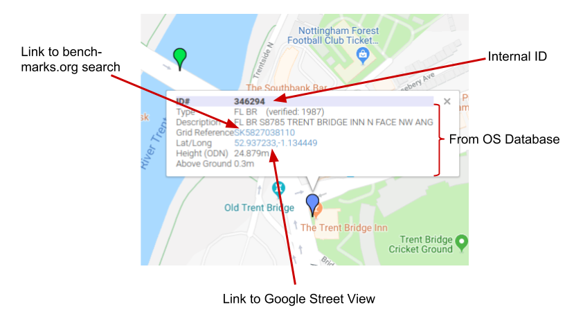
The Google street view link lets Google select the closest street view it has to the location passed. For a roadside mark, this ought to open close to the mark's location (you will be placed
at the south-west corner of the 10 by 10 square, facing north-east), however for more rural locations you might be placed a long way from the actual grid reference.
Map Layers
The top left-hand button enables different map overlays to be used. The first three are from Mapquest, and usually the most responsive.
OS Open Data
The fourth overlay relates to OS Open Data maps, supplied by the Ordnance Survey. At zoom levels up to 50m (see scale on bottom left of map) the data is provided for free, but at the two highest zoom levels (30m and 10m scale) - when height markers first appear - there is a cost associated with each
map 'tile' shown, with a certain monthly quota being free. To avoid costs (to me!) when this quota is used up, the two highest zoom levels for this map will be
disabled (the map will either not be selectable, or the screen will be grey). Zoom out to a lower level, or switch layers, to return to a map display.
You can help me by using the larger scale (i.e. 50m plus) zoom for general navigation, and only zooming in to 30m or 10m when you're at the relevant location.
The 'OS Open Data' map layer is shown in red in the selection list to indicate that it's different to the others.
Clicking the 'Show overlay' next to the layer selector, enables one of the the three Mapquest map styles to be shown along with whichever map layer is currently selected.
The visibility of the overlay can be varied by using the slider just below this option. This can be useful when trying to identify historical marks against current land features.
Searching
At the top-left of the page (below the map-type selector) is a search box.
Enter a UK postcode to re-position the centre of the map on that postcode, or enter a specific benchmark Id to go to that benchmark (or a Trigpoint Id - Tnnnn - to go to a trig point).
(there is also limited support for searching benchmark descriptions ... if text not matching postcode format is entered, this will be used to match against the benchmarks' descriptions)
Search results are limited to the first 20 hits.
Cookies
This site uses a cookie to store the map centre, so that re-opening the webpage returns to the last position viewed.
No personal data of any kind is stored or used by this website.
© Hard Solutions, 2019-2024. Contact: enquiries@hardsolutions.co.uk.